Forecast
Tonight's Forecast
Thursday 28th August
some of the faulty links have at last been repaired
Rain radar is showing that most of the blue patches have cleared our region as they move away to the NE. Much further out to the WSW there are more blue patches moving ENE
Visual and infrared satellite images are showing clear periods with varying amounts of cloud. The cloud is coming in from the W
n spite of receiving live visual and infrared satellite pictures every 15 minutes the cloud is still sometimes difficult to predict when and by how much the cloud is going to break up
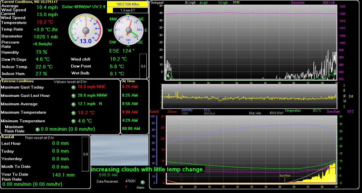
Note. Temperatures are taken at 1.25mtrs above the ground on a north facing wall
A warm evening with further sunny spells / periods. Any remaining showers clearing to the NE. Staying dry after dark with clear spells. Cloud increasing from the WSW / SW overnight bringing a high chance of further scattered thundery showers during the early hours.
Minimum temperatures 14 to 13C,
Winds from a WSW / SW later SSW / S direction will be brisk at first moderating to light by late evening.
A cloudy, dull and wet start for tomorrow with outbreaks of showery rain at first. Showers then clearing to the E by mid to late morning to give a mixture of dry / sunny spells and further scattered showers in places. UV HIGH and Pollen LOW
Warm with top temperatures eventually reaching 21 to 22C.
Winds from a SSE / S later SW / WSW / W direction will be very light increasing to light by early afternoon,
The temperature at 6.08pm was 20.2C, humidity 60% and the barometric pressures 1000.4mb's and falling very slightly
Top temperature today was 22.3C
Last gust was 22mph WSW
Max gust today was 27mph at 12noon
Rain for January was 68.5mm
Rain for February was 42.2mm
Rain for March was only 3.6mm
Rain for April was 28.8mm
Rain for May was 17.1mm
Rain for June was 27.2mm
Rain for July was 56.8mm
Rain yesterday was 0.2mm
Rain so far today was 0.2mm
Rain so far for August is 1.7mm
Rain year to date is 247.8mm
Rain for 2024 was 676.7mm which was above average for this area
Rain for 2023 was 713.4mm which is above average for this area
Rain for 2022 was 572.7mm which is average for this area.
Rain for 2021 was 642.9mm which is slightly above average for this area.
Rain for 2020 was 607.4mm which was about average for this area.
Rain for 2019 was 696.3mm which was above average
Rain for 2018 was 617.8mm which is slightly above average
Rain for 2017 was 707.7mm which is above average for this area.
Rain for 2016 was 586.7mm which is average for this area.
Rain for 2015 was 581.6mm which is average for SW Essex
Rain for 2014 was 881.4mm which is an all time record for this area..
Rain for 2013 was 727.2mm which is above average for SW Essex.
Rain for 2012 was 858.9mm which was high for this area.
Rain for 2011 was 417.5mm which is very low for this area which normally has around 525 to 575mm
Last updated at 6.08pm Thursday
Next update at 0645BST
